Below is this morning's bulletin from the National Hurricane Center:
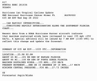
617
WTNT64 KNHC 281036
TCUAT4
Hurricane Ian Tropical Cyclone Update
NWS National Hurricane Center Miami FL AL092022
635 AM EDT Wed Sep 28 2022
...IAN RAPIDLY INTENSIFYING...
...CONDITIONS RAPIDLY DETERIORATING ALONG THE SOUTHWEST FLORIDA
COAST...
Recent data from a NOAA Hurricane Hunter aircraft indicate
that maximum sustained winds have increased to near 155 mph (250
km/h). A special advisory will be issued by 7 AM EDT (1100 UTC) to
reflect this change and update the forecast.
SUMMARY OF 635 AM EDT...1035 UTC...INFORMATION
----------------------------------------------
LOCATION...25.9N 82.8W
ABOUT 65 MI...105 KM WSW OF NAPLES FLORIDA
ABOUT 80 MI...130 KM SSW OF PUNTA GORDA FLORIDA
MAXIMUM SUSTAINED WINDS...155 MPH...250 KM/H
PRESENT MOVEMENT...NNE OR 15 DEGREES AT 10 MPH...17 KM/H
MINIMUM CENTRAL PRESSURE...936 MB...27.73 INCHES
$$
Forecaster Papin/Blake
Here is the link: National Hurricane Center Hurricane Ian Bulletin
Hopefully, you are reading this from a place of safety. This is stronger than I think anyone expected. There were some projections of a Category 4 storm, but this is just 1 mph from Category 5 strength.
Hurricanes are notoriously unpredictable in spite of our increased technology and data. They change speed, direction, and intensity without much warning. You should take every one of these storms seriously. Always have a pre-packed bug-out kit ready to go.