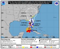
Hurricane Ian is growing in size and maybe even strength for landfall. My best source has been stating that the storm will not rapidly weaken after coming ashore and will likely still be a Category 2 storm when it reaches central Florida. More bad news is that the cold front that kept it from the Tampa area, is slowing the storm down. That means there will be more time for the winds to build storm surge. This is not good. Please look at your evacuation plans seriously.
So, we have at least a Category 3 hurricane hitting between the Ft. Myers and Cape Coral areas tomorrow. Large portions of the Florida peninsula will be feeling strong effects from the storm over the next 24-48 hours.
Please take care and enact your But Out or Bug In plans now.