Okay guys, here are the latest takeaways from my sources. One of the sources has been the most accurate with this storm, so we will feature those.
- The three major models:
- HRRR - landfall at Northport at 12 PM.
- ECMWF - landfall at Sarasota tomorrow night.
- GFS - landfall at Northport early Saturday morning.
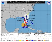
- Landfall will be as either a Category 3 or 4 storm.
- Maximum rainfall of 15"-20" from Fort Myers to Northpoint.
- At 2:00 PM today, sustained winds were 120 MPH with gusts to 140 MPH.
- For perspective, Hurricane Irma produced gusts as high as 142 MPH.
- Some models show the storm heading east across Florida with a second landfall in the Carolinas.
- If it does it could re-energize and present a real threat.
- Expect widespread power outages and flooding.
Tip: If your power goes out and you have to manage your cell phone's battery closely, consider calling someone outside of the danger area now and setting them up as your point of contact for everyone else. Tell them that if the power goes out, you will likely turn off your phone and only text them at certain times of the day to give them your status and other communications. If you try to leave your phone on all the time, you will run your battery down much faster than you want. Even though you may think you need to be in constant contact, you don't. Be smart. Once the power is available again, you can talk until you wear your phone out. For this, it is a valuable tool to protect you and your family. Treat it that way.